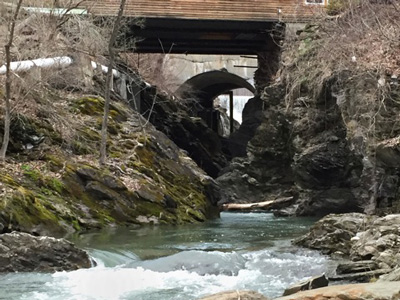
Boundary Surveying & Mapping
Boundary Surveying & Mapping is the geosciences of providing Licensed Land Surveying Services to determine the accurate boundaries of real property. Read more...
When generating a recordable boundary survey plat, the surveyor must research deeds, filed surveys, title certificates, easements, servitudes, rights-of-way and/or subdivision maps of record at the local land records office. Physical measurements of the property utilizing high precision survey instrumentation are then performed in the field. The recorded evidence is compared against the physical evidence to determine if there are any discrepancies between them. Once the surveyor has resolved any discrepancies that may have existed, the boundary line/corner is then permanently set in the field and recorded on a new boundary survey plat.
A boundary survey is recommended for our clients before buying, subdividing, improving or building on land. Other forms of boundary survey plats offered by this office are GPS Surveying, Existing Conditions/As-Built Surveys and ALTA/NSPS Surveys.
GPS Surveying
We recommend utilizing our GPS surveying services for all surveying service - specifically for those clients who need a FEMA Elevation Certification of LOMA, Aerial surveys or Road construction surveys. Read more...
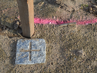
Point of Beginning utilizes the latest and most up to date advanced high precision survey equipment on the market today. We continue to invest in the latest developments of Global Position System (GPS) technology and are one of a handful of surveying firms in Vermont utilizing the combined robotic total station/Real Time Kinematic GPS surveying equipment put out by the Swiss company Leica. The combination robotic total station/RTK GPS equipment utilized by this office enables our one person survey crew to complete projects up to 40% more efficiently than most of our competitors 2 two person crews.

(Photo Credit - Alec Marshal)
Flood Elevation Certificates
If your property is located within a flood hazard zone as determined by FEMA you may be required to complete a flood elevation certificate in order to purchase flood insurance, as a part of the sale of the property or as a part of a new construction or remodeling process for a building. Read more...
A Federal Emergency Management Agency (FEMA) elevation certificates (EC) is an administrative tool of the National Flood Insurance Program (NFIP) which is to be used to provide elevation information necessary to ensure compliance with community floodplain management ordinances. It is required by most insurance agents to determine the proper insurance premium rate that reflects your risk. A flood elevation certificate helps clients to determine the precise location of their property in relationship to the base flood elevation (BFE).
An elevation certificate (EC) measures and records the elevations around a property and compares those elevations to the floodplain elevations determined by FEMA. This process allows owners to demonstrate compliance with flood plain management ordinances, and helps an insurance estimator or public officials determine the actual flood risk to a property. Point of Beginning has over 12 years experience working directly with FEMA and has worked hard to establish a solid working relationship with representatives at FEMA to who know and trust our level of work relating to Elevation Certificates applications submitted to them by this office. Elevations must be certified by a Registered Professional Engineer or Licensed Land Surveyor if the Elevation Certificate is intended to support an application for a Letter of Map Amendment or a Letter of Map Revision Based on Fill - We recommend that our clients who think they may need a Flood Elevation Certification (EC), a Letter of Map Amendment (LOMA) or a Letter of Map Revision (LOMR) to contact us to see how we can help.
Existing Conditions Survey & As-Built Survey
We recommend an As-Built survey for our clients prior to the purchase of a commercial piece of property to insure that what is being listed by the seller or the sellers agent has been listed and described accurately and for any of our clients in the construction community. Read more...
An Existing Conditions Survey is a pre-construction survey that is performed to document conditions of the project site prior to the commencement of construction. An As-Built survey is a survey that may be conducted to show the current state of a project at various stages throughout the life of a project. An As-Built survey may also serve as a “close-out” document to verify that the work that was authorized has been or is being completed in accordance with the engineered or architectural drawings and/or are in compliance with all state and local permits and regulations.


ALTA/NSPS Survey
We recommend an ALTA/NSPS Survey clients whose insurers have specific needs related to title insurance matters or those clients that who would like a more detailed survey than above and beyond the typical As-Built survey. Read more...
Insurers have specific needs related to title insurance matters, and when asked to provide an insurance policy without any exception relating to survey matters, a set of standards governing ALTA surveys was developed by the American Land Title Association (ALTA) and the National Society of Professional Surveyors (NSPS). The ALTA Survey is a detailed map of the land showing all existing improvements of the property, utilities, and significant observations within the insured estate. Point of Beginning will prepare a survey detailing our findings concerning the property boundaries and how it relates to title. The Survey delineates or makes note of all easements and exceptions cited within the title commitment for insurance of the secured party.
The survey may also show zoning and flood zone restrictions or areas indicating potential future use of the property. The ALTA survey is a combination of a boundary survey, title survey, and a location survey. The ALTA standards govern the content of all ALTA surveys and are denoted in the "2016 MINIMUM STANDARD DETAIL REQUIREMENTS FOR ALTA/NSPS LAND TITLE SURVEYS" as adopted by American Land Title Association and National Society of Professional Surveyors.
Topographic Surveying & Mapping
We recommend a topographic survey for our clients who plan on utilizing a Civil Engineer, Architect or Landscape Architects. Read more...
Topography Surveying & Mapping is the geosciences of recognizing, gathering and representing landform patterns. Point of Beginning uses a Robotic Total Station and/or a Real Time Kinematic high precision GPS receiver to locate all surface features of a property. Once the physical information is gathered, we will utilize a computer aided drafting (AutoCAD) program to generates a 3-dimensional map of subject property showing all natural and man-made features and improvements specifically the location, size, height and any changes in elevation.
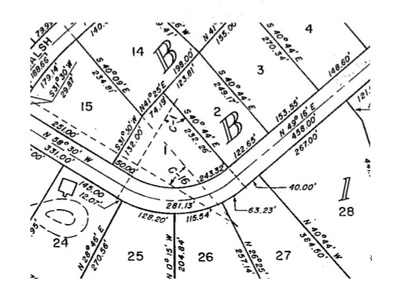
Boundary Line Adjustment
Many towns in Vermont as well as the State of Vermont Department of Environmental Conservation require a boundary line adjustment permit application be prepared and approved prior to any boundary line adjustment is finalized. Read more...
A Boundary Line Adjustment (BLA) is the process for adjusting property lines between pre-existing contiguous properties. This process does not create a new lot. Normally a boundary survey depicting at least one of the lots being adjusted is required to be submitted with the application showing the Pre & Post adjustment of the property.
Septic & Well Design
This type of required permitting is called a Wastewater systems and Potable Water Supply Permit or commonly known as a WW permit or Perc testing. Read more...
As a licensed Class A septic designer I am authorized to do all aspects of site evaluation, soil and percolation testing, application preparation, septic system and water supply design as well as certifying the construction and installation of these systems.

Permit Preparation
Most towns in Vermont have Zoning and or Subdivision regulations which require approval from the local planning authorities before any land use or development may occur. Some examples which may require a permit include The division of a parcel into two or more parcels; The construction, structural alteration, relocation or enlargement of any building or other structure; Any mining, excavation or land filling of a parcel(s); Any change of use of any building or other structure of land, or any extension of the use of the land.
Water permits | ACT 250
State of Vermont Wastewater Systems and Potable Water Supply Permit
Per Chapter 1 of the Wastewater System and Potable Water Supply Rules, no person shall take or cause to be taken any of the following actions without first obtaining a permit or permit amendment from the Secretary:
- The subdivision of a lot or lots;
- The construction of a new potable water supply or wastewater system;
- The modification or replacement of an existing potable water supply or wastewater system;
- The construction of a new building or structure;
- The modification of an existing building or structure in a manner that increases the design flow or modifies other operational requirements of a potable water supply or wastewater system;
- The connection of an existing potable water supply or wastewater system to a new or modified structure;
- The change of use of a building or structure in a manner that increases the design flow or modifies other operational requirements of a potable water supply or wastewater System including the conversion of a single family residence from seasonal to year-round use;
- The creation of a campground;
- The modification of a campground, including the creation, modification or relocation of one or more individual campsites, in a manner that affects a potable water supply or wastewater system or the requirements for providing potable water and wastewater disposal;
- The use or operation of a failed potable water supply or failed wastewater system; or
- The commencement of construction of any of the above. For the purposes of this section, commencing construction means any work involving the physical construction or modification of a building or structure and its associated potable water supply or wastewater system including, but not limited to: foundation excavation; foundation or building construction; and site work that involves or may affect any portion of the existing or proposed potable water supply or wastewater system serving the project.
State of Vermont: Act 250 Permit
Act 250 is a comprehensive law that evaluates the impact of a development project under a number of environmental criteria (see the 10 Criteria below). Approximately 600 - 700 Act 250 applications are submitted each year throughout the state. The good news is that approximately 95% of these applications are approved. An Act 250 permit is required for certain categories of development, such as subdivisions of 10 lots or more, commercial projects on more than one acre or ten acres (depending on whether the town has permanent zoning and subdivision regulations), and any development above the elevation of 2,500 feet. If you feel you may trigger the need for an ACT 250 permit, the District Commission must ensure that the development or subdivision satisfies the following 10 criteria:
- Will not result in undue water or air pollution.
- This criterion deals with water and air pollution generally and such specific matters relating to water pollution as: (A) Headwaters; (B) Waste disposal (including wastewater and stormwater); (C) Water Conservation; (D) Floodways; (E) Streams; (F) Shorelines; and (G) Wetlands.
- Has sufficient water available for the needs of the subdivision or development.
- Will not unreasonably burden any existing water supply.
- Will not cause unreasonable soil erosion or affect the capacity of the land to hold water.
- (A) Will not cause unreasonably dangerous or congested conditions with respect to highways or other means of transportation. (B) As appropriate, will incorporate transportation demand management strategies and provide safe access and connections to adjacent lands and facilities and to existing and planned pedestrian, bicycle, and transit networks and services.
- Will not create an unreasonable burden on the educational facilities of the municipality.
- Will not create an unreasonable burden on the municipality in providing governmental services.
- Will not have an undue adverse effect on aesthetics, scenic beauty, historic sites or natural areas, and 8(A) will not imperil necessary wildlife habitat or endangered species in the immediate area.
- Conforms with the Capability and Development Plan, including the following considerations:
- The impact the project will have on the growth of the town or region: (B) Primary agricultural soils; (C) Productive forest soils; (D) Earth resources; (E) Extraction of earth resources; (F) Energy conservation; (G) Private utility services; (H) Costs of scattered developments; (J) Public utility services; (K) Development affecting public investments; and (L) Settlement Patterns.
- Is in conformance with any local or regional plan or capital facilities program
Property Consulting
At Point of Beginning we are very much aware of the required local and state regulations we are operating in. As a Property Consultant we feel confident we can provide you with the proper assistance you may need for whatever kind of project you are looking to do.